Timanfaya – Fire Mountains
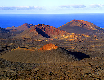
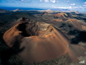
 Between 1730 and 1736, Lanzarote has been affected by volcanic eruptions which form part now the National Park of Timanfaya – The Montañas de Fuego (Fire Mountains)
History tells us that more than thirty volcanoes violently exploded, spilling fire, smoke and huge masses of magma onto the surrounding landscape, burying entire villages. Fortunately, people had already deserted their homes in time so that despite this natural catastrophe, there were no casualties. These eruptions transformed almost a quarter of the island into a sea of solidified lava, multicoloured volcanic rocks and copper-coloured sand, with wide areas covered with thick layers of lapilli (coarse ash). These materials formed the malpaís (badlands), and more than 250 years after these eruptions, there is still hardly any vegetation here.
 Since it was formed, the people living on the island have had to learn how to coexist with this unusual landscape, and they even grow dryland crops such as melons, onions, tomatoes and vineyards in the area of La Geria.
Named after a village that was one of the eleven settlements that were buried by lava and ash during the volcanic eruptions, the National Park of Timanfaya was declared a protected National Park in 1974.
The grandiose, multicoloured volcanic landscape enclosing the Montañas del Fuego (Fire Mountains) stretches around 51 square kilometres.
This amazing lunar landscape is a must see for any Lanzarote visitor !
Ce contenu a été publié dans
Uncategorized. Vous pouvez le mettre en favoris avec
ce permalien.


 Between 1730 and 1736, Lanzarote has been affected by volcanic eruptions which form part now the National Park of Timanfaya – The Montañas de Fuego (Fire Mountains)
 Since it was formed, the people living on the island have had to learn how to coexist with this unusual landscape, and they even grow dryland crops such as melons, onions, tomatoes and vineyards in the area of La Geria.